Eldorado - NE Face
Here it was, early October, and the forecast for saturday was beautiful blue skies, and reasonably warm temperatures. So after kicking around some route ideas, Phil and I descided on the NE Face of Eldorado, near Cascade Pass. The late season and the recent cold weather would likely have produced great ice conditions up on this moderate looking face. Phil and I were totally excited because we might actually summit something! whoa! Our track record recently hasn't been so hot, as is noted by the lack of recent trip reports.
We left Seattle on Friday night after taunting Phil's roomate's dog "Biner", and made a b-line for the HUGE parking lot about 19-20 miles up the Casecade River Road. All the while Phil is trying to get me to drink some of his "magic Kava drink!" from Trader Joes. Just a short quote from the label brings to mind things other than wholsome herbal fruit drinks: "Kava may slow your reaction time. Driving while drinking Kava may be in violation of the law." What the heck?! Needless to say, Trader Phil's magic drink was rejected.
After self registering at the ranger station, we pulled into the parking lot far up the road. A great, and somewhat popular bivi spot for people coming up to Eldorado and Boston Basin, meant this parking lot was a little less than quiet that night. However Phil and I were up to the challenge: wake up at 5:45! ugh! We had descided to get up early Saturday and try to do the entire climb in one day, and then camp up high. This way we could take advantage of the good weather window for Saturday, and escape climbing in the poor weather predicted for Sunday.
First off, Jim Nelson's eye sight must be getting bad, because the "obvious trail into the woods" that includes a makeshift trailhead sign, is not more than 100 feet away from the parking area! Far less than the 300 yards or so that he mentions. Perhaps the parking lot has changed with time, but either way, there is a huge bomber tree that lease across the river. Beta for crossing the log: goto the south side, stem off the rotting tree, look up and left for the "jug" and do a two-armed-beached-whale approach to getting on the log. The trail on the other side is too obvious to mention, and it just goes up from there. When we had arrived in the parking lot, a fellow had described our approach as "*%&&!ing strait up!", and "Brutal!". As we walked along the well beaten climber's path snaking up through the old forrest, we didn't think that it was brutal at all. In fact, we thought it was a walk in the park compaired to what we were used to! So up we went, making good time on the first 2,000 feet to the first boulder field. Pretty obvious boulder hopping from here lead to a much larger and longer boulder field that paralleled a long cliffy ridge. Sometimes following carins, mostly not, we worked our way up and along the solid granite boulders until it ended at small and beautiful waterfalls. At this point, because of the abundance of water, you could probably do this climb with one water bottle (save ya 2 pounds?). From these waterfalls the trail began again and led up into beautiful heather meadows.
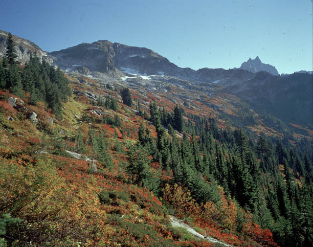
View of Mt. Torment and the alpine meadows.
We continued up the meadows, eventually climbing some nice granite slabs to a pass overlooking the Eldorado Glacier, and our objective for the day, the summit! At this point, our elevation was around 6,100 feet. Roughly 4,000 above the parking lot, and we weren't nearly there yet! The summit was still almost 3,000 feet above and our face happened to be on the other side of the mountain. No problem, nah..
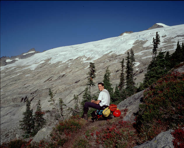
The totally cool Eldorado Glacier.
After a quick descent of a 4th class slab, we were hiking up the talus, and then the toe of the glacier. But wait! What's this?? Phil has spotted a Platypus bladder! Too bad Marcus wasn't along for the trip, he could have used it high up where the tube would freeze! (no I won't ever let you live that one down!) for more info, see the Liberty Ridge trip report. So a score for Phil, even though it's probably nasty and was used as someone's "Pee bladder."
The glacier at this point is pretty begnign so we descided to just hike up with crampons on and no rope. I was a bit dissapointed at this because the rope was on my pack! Oh well, so after passing up many nice, flat, wind-protected campsites around 7,100 feet, we settled in at around 7,400 feet at a very windy and cold glacial pass. (I won't say who's idea it was to camp so high!) This appeared to be high enough to set up camp for the night, so we took a rest and empied our packs into the nearby rocks. It was 12:00 pm. In 5.5 hours we had come up 5,200 feet. Our legs began to cramp as we rested for the upcoming climb.
Me and the magical floating ice screw. I didn't
know those Titanium screws were THAT light!

After a luxourious hour and a half rest, we were off from the windy-crevasse camp.
Leaving Camp, early afternoon. hmmm, a little
warm out here for ice climbing eh?

Yes, it was a bit warm out, but hey, it was a beautiful day and we had the entire mountain to ourselves. As we countoured onto the Inspiration Glacier, which Makes up the NE side of Eldorado, we encountered some monsterous crevasses! One in particular was easily 80 feet wide, and spanned almost the entire glacier. Going far to the N to detour this one, we were already spying routes out onto the NE Face looming above. The face its self is relatively short, maybe only 600 feet from the berschrund at the bottom, to the summit. However, several impressive crevasses and icefalls scar the face and make it a worthy challenge.
Somewhat to our dismay, there was about 3 inches of soft snow on top of the otherwise rock hard glacier ice. That's what you get in October I guess! So we headed for the most obvious weaknesses in the overhanging walls of the scrund at the bottom of the face. We climbed into the scrund on sketchy fallen blocks, and I set in a belay to bring phil up. From here, directly above us was a sweet overhanging wall with "ripples" that would allow great footholds. I was psyched! Racked up and ready to go, I made two moves up the 60 degree-ish ice to the base of the ripples. The wall was only about 15 feet tall, but the awkwardness of tool placements on the "ripples" themselves really sucked! The attractiveness of this particular section had become it's downfall. Quickly losing confidence, I detoured right on some very exposed and super brittle ice into a little nook. From here it was easy jaunting up a 50 degree ramp out on to the NE Face proper!
On the Ramp de Jour.
Phil followed up quickly and soon we were climbing up frozen snow, only a handfull of ropelengths below the infamous knife edge summit ridge.
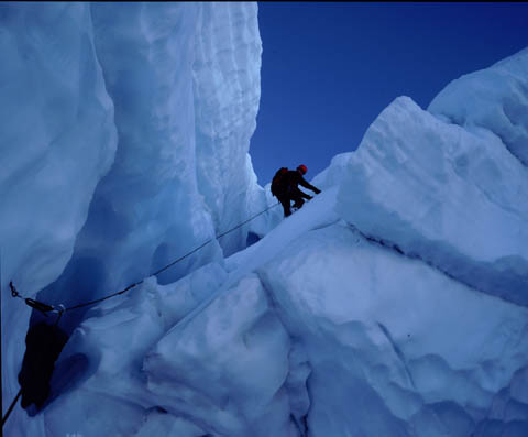
Climbing on the NE Face with unseen, but extreme
exposure off the icecliff to the left.

Near the top of the face, we detoured over to check out the NW Coulior mentioned in Nelson's new guide. Supposidly the other two in the parking lot were headed up to do this route. It looked thin, dirty, but doable! Have to give this one a try someday.
The Northwest couloir, and aparently, the sun!

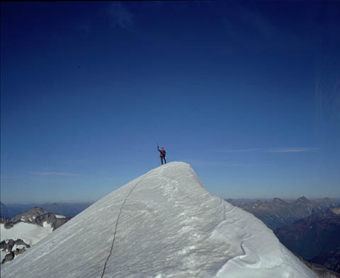
The summit was now only 100 feet above us, and it looked every bit as cool as I had heard. The image of Phil, gently kicking up the spindrift off the icy knife edge ridge, while sillouetted by the setting sun will be one of the most beautiful sights I remember seeing in the mountains. We'd made it. Tired, cramped, hungry. But happy.
And then back down.

The descent, and thus the standard East ridge route was pretty trivial. A little steep snow, but nothing too bad, and in less than an hour, we found ourselves back at the windy-crevasse-camp. It is so called because our heads were located over a small 2" crevasse in the pass, and of course, it was always damn windy there. It was now about 6:30, an hour before sunset, and just shy of 12 hours from the car, and we were back at camp! Good old "Mama Phil" cooked up water and food for our very dehydrated bodies, and after an hour or two we were both in our bags trying to sleep.
For some reason Phil insisted that his dinner of Macaroni and Cheese from Trader Joe's was called "Kraft Dinner!" He would not listen to reason. Crazy northerners! He liked it so much that he left a small amount of Kraft dinner "juice" in the pot for morning.
The night was long, about 13 hours, and a little unconfortable due to the wind flapping the tent all night, but at least it was warm! Had we brought our bivi sacs we would have both been freezing, miserable and cold. Get the picture? :)
As clouds rolled in on Sunday we quickly packed up and headed down. On the way down through all the steep trails and boulder fields, we learned why the older guy had described this trail as "brutal". It took almost as much effort to go down as it did up! ugh. Many hours later, tired and hungry, we emerged out of the bush to the parking lot.
Oh! What's this? A ticket from the forest service for illegally parking at this "trail head". Hmm.. What about an old truck turn-around with no signs and no actual trail makes this a trailhead? I'll hang it up in my cubicle to remind me of spending those lovely October days in the high mountains with a good friend.