|
Liberty Ridge
Liberty Ridge on Mt. Rainier's North face definitely deserves the
title of "classic". On June 15-17, Phil, Marcus and I lucked out and
has three perfect days of weather and climbing on Rainier.
To start out, Phil had the "zany" idea that we should cache a couple
beers in Glacier Basin for the return trip. An excellent idea! So three
beers were slogged up to a secret tree stash and left for later fun
and games (see below).
When we arrived at the Ranger station on Thursday morning, we were
(to our surprise) the last permittable group for a Thursday to Saturday
climb! We had filled up the rest of the spots on Curtis ridge and Thumb
rock. Odd we though, isn't this mid-week climbing??? Upon driving to
the parking lot at White River, we met four climbers who were also intending
to do the ridge. They seemed to have pretty big packs, so we broke out
Phil's scale to weigh ours, and then theirs. Phil Marcus and I were
all clocked in at around 40 lbs with 3+ days of fuel and food. Their
group of four had a range of experience that was proportional to pack
weight. This ranged from about 45 to 55 pounds! (FULL Mountainsmith
pack!) These people were mysteriously still on the mountain when we
got back to the car. (Too bad it was raining the next day!)
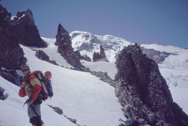
Dave at St. Elmo's Pass. Photo: Phil Fortier
Marcus proudly showed off his new "hydration system," I think he called
it, that was a 3 Liter platypus. Phil and I both thought it was cool,
but warned him of the tube freezing that occurs at altitude. Undaunted,
he carried it up the trail. Our delightful first day was spent climbing
up to St. Elmo's pass out of Glacier Basin, and then dropping down onto
the Winthrop Glacier for a long traverse to the Curtis ridge camp at
7,200 feet.

Traversing lower Curtis Ridge. Photo: Phil Fortier
This went pretty quick (5 or so hours) and the campsites were very
nice level dirt spots with awesome views of Liberty Ridge and the Willis
Wall. After chatting with a cool Father n' Son team from Denver, we
headed out onto the infamous Carbon Glacier for a reconnaissance of
the route up to the ridge. A short route through the massively creaky
icefall was pretty easy to find, but we didn't go any further due to
the mushy snow and lazy-factor.

Taking in the awesome North face of Mt. Rainier and the Carbon glacier.
Photo: Phil Fortier

Hans n Frans hanging out at camp. Photo: Marcus Collins
After much haggling, day two began at 5:30 am. I must say, Marcus and
Phil were right in wanting to get up so early for the seemingly short
and not-sun exposed climb to thumb rock. I say this because there are
two flat spots at thumb rock, we were first to get there that day, and
we got spot #2. The crossing of the Carbon was pretty easy, only involving
a few sometimes tricky snow bridges and a little routefinding. Once
at the base of the ridge we climbed a short rock step to gain a direct
start at the 30-40 degree slopes.

Starting up the ridge. Photo: Phil Fortier
When climbing the lower sections of the ridge, it is probably best
to bypass all rock bands on the right (west) side of the ridge. We went
left (east) once and regretted it due to the ton of mushy sun-warmed
snow that we encountered. But after regaining the ridge crest and crossing
back onto the shaded (west) side, we climbed up the awesome 1,000 foot
frozen snow slope directly up to thumb Rock. It took us about four and
a half hours from camp at 7,200 to get to Thumb rock at 10,760. It is
possible to do this in a long day, however it means a long day (10+
hours) and a lot of strenuous elevation gain (about 6,000 feet). We
decided that we would avoid AMS at every chance we could, thus doing
two leisurely approach days.

The narrow camp spot #2 at Thub Rock. Photo: Phil Fortier

Avalanche on Willis Wall. Photo: Phil Fortier
From Thumb Rock up is were the real cool climbing begins. Because the
"ice step" route up the main gully for the usual route was totally out
of condition, we opted for the exposed 40 slope to the left of the rocks
above camp. Leaving first from camp at 1 am, we were the pioneers of
the route for the day. Phil even admitted after the climb that he thought
of himself as a new age Ome Diaber!

Phil climbing up out of the darkness below the Black Pyramid.
So on we climbed through the night up frozen and very hard snow until
we reached a series of rock bands that seemed to span the whole slope.
After taking about which way we thought we should go (all route descriptions
were left at home... on purpose. yeah. sure!) we found some tracks leading
strait up. The rock bands were surmounted fairly easily with a few cool
4th class moves up a step and then traversing left towards the infamous
steep slope below the Black Pyramid. After a quick break at a good potential
emergency bivi (about 12,000 ft.) we headed on to the 50 ice slope.
The snow was in great shape, and we cruised on up the section of a couple
hundred feet with only planting a few pickets, as Beckey would say,
for safety.

Steep ground past the Black Pyramid. Photo: Phil Fortier
At 13,000 ft there is a good rest, and so we stocked up on Gu and energy
bars and looked at the very near and impressive ice cliff. At this point
some un-named-permit-less-people-that-i-knew-with-few-manors passed
us and headed up to the first pitch of the ice cliff. Phil lead the
short step which only involved about 10 feet of very steep ice, and
then low angled water ice above.

Following the crux step. Photo: Phil Fortier
I say water ice because of the weird condition that the surface of
the snow was in. For some reason the slope was covered with this brittle
globular network of water ice. Very similar to big ice-cubes, but hard
to walk on without kicking all hell loose on the people below. So we
endured the usual amount of ice falling off of people on the pitch above
us without complaint. Above the step there is one last steep slope to
climb up over the 'schrund and onto Liberty Cap's summit.

The party behind us just below the summit of liberty cap. Photo: Phil
Fortier
This team a head of us (now earning their few-mannors title) topped
out and starting sending down just torrents of these ice blocks. After
our team and another team screaming obscenities at the top of our lungs
for them to stop moving, AND hearing a reply, the torrents continued.
Luckily the "kicking" party got off the summit and descended the Emmonds
before the other party being pegged with us was able to "talk" with
them. Talk about potential blows at 14 K!

Phil taking the last few steps to the top.
Ahh the summit, at last! All of the major exposure and fear were left
behind and were were in a flat, windless and warm world. It was so nice
in fact, that we all (minus Phil) said hello to Mr. Hankey. As we all
would soon find out, Phil would see Mr. Hankey later! The route in all
took us 7 hours, with some waiting for other parties. If we didn't have
to wait it may have been a little under 6 and a half. The descent of
the Emmonds Glacier was delightfully uneventful. Seeing as we had left
the map in the car, and the route descriptions in the books, we were
happy to follow "the highway" down the route. One interesting thing
to note was the people coming up's start time, especially those who
though 7am sounded good!
After making it down to Sherman and talking with Dee, one of the seasonal
climbing rangers, we headed towards the Inter-glacier for the descent
and a little "fun". Marcus showed Phil and I a fancy trick the he and
his brother Nathan invented for speedy descents. Still roped up, Marcus
in the middle and Phil and I on his left and right sides, he took off
down the hill running. Soon Phil and I were reaching warp speed down
the glissade tracks. Then disaster. A unexpecting team was sauntering
the slow way up the glacier. Here we were, three guys spanning 50 meters
of the slope and traveling at about 15 mph right at them! Essentially
we were the dental floss and they were the plaque! Well, real disaster
was actually avoided due to the lessing of the slope angle at the team's
position. The disaster was that we looked like total yokels! This turned
out to be true and only the begining of such activites.

And the beer Cache... Photo: Phil Fortier
The beer was then located in the melting-out-secret-hill-side-pub and
we relaxed in the sun with our beers and successful climb. Liberty Ridge
was spectacular, exposed, remote, challenging, strenous, and fufilling.
What better way is there to spend three sunny days than climbing and
spending time with friends.
|