Mt. Maude - Entiat Icefall
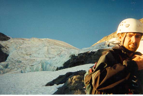
Len and the Entiat Icefall
The Entiat Icefall is a challenging route with true alpine style. Approach Icy Lakes via the Phelps and Leroy Creek trails (unmarked but there), and camp below the South Ridge route at bivi ledges. Cross talus slopes above Icy Lake to reach the notch that allows access to the Entiat Glacier. Rope up and descend to find a short crossing through abalition zone on receding glacier. This crossing is much trickier than Beckey's picture shows. Skirt below the rock spurr and head up towards the Icefall. Working rightward under the pictured headwall, continue through big crevasses with short vertical steps. Above are gentiler 35 degree ice slopes to the base of the rock. There are several ramps to start off with on this 900 foot portion of 4th and low 5th class rock. Pick the line of least resistance leading slightly toward the ridge crest. The rock is generally crumbly, and protection is scarce. Running belays are the method of choice here. There is an interesting step-across at the top of a couloir (Yoder?). Finally a short walk to the heavily carin'd summit! Give 5 to 7.5 hours to here. Descend the South Ridge, this took 30 minutes max!

Mike Leading off
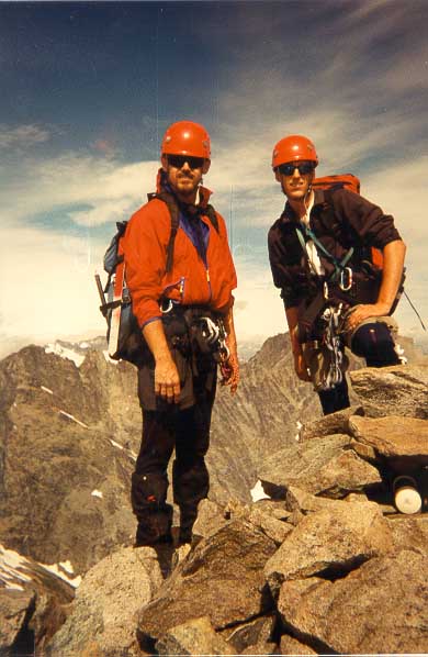
Mike and I on top!
Trip Report
August 28-29, 1999
After getting a leisurely 7:00 a.m. start from Seattle, Mike, Len and I arrived at the Phelps Creek trail head around 10:30 a.m. The end of the road parking area was packed with cars and people. After checking out the Leroy Creek trail’s existence, we headed out in a swarm of bugs. The approach to Maude can be a bit confusing, especially without someone else’s advise. The shortest way in is through the Phelps Creek trail, which connects to the unmarked and well worn Leroy Creek trail. The trail empties into a basin directly under Maude and Seven Fingered Jack. From here, we followed a small climbers path to a notch at around 6,900 feet. We figured this was the notch at about 7,200 feet described in Beckey’s guide. This error later helped us make a long detour in the wrong direction up an ugly scree bash. At the pass we encountered an old man hiking up to climb Maude. He carried a old mining map of the area and a bunch of interesting history to go along with it. I suppose there is reason to keep old guys around. J After talking for a half hour or so, we packed up and headed out towards the lakes. Finally, after four thousand feet and six hours in our own personal bug cloud, we found a great bivi spot above the South side of Icy Lake.
Our position was ideal for the South Ridge route, which was to be our descent route. However, to reach our desired route, we had to traverse to the other side of the mountain! The route included a long scree bash over a cliff band to a notch. At this time, Mike told us about his knees. We then decided on cushioney time estimates for the next day’s climb. Due to the fact that both the Icefall and the North Face are committing routes, we decided to set an early turnaround time at the notch. If we could not make it to the notch in two hours from camp the next morning, there would not be time to complete the route and descent to the cars. Thus, the clock was ticking.
After two brief rain storms and thoughts of going home, we were up at 4:00 a.m. under clear skies. After most of the scree bash was complete, Mike decided that he was having another infamous "bad hair day." But we decided to continue onto the notch over a short snow slope anyway. By now, I had not contributed much in the way of danger to the climb. So, when we came upon a brief patch of ice, I decided to show off my ice skating skills. With thoughts of sailing across the ice with a running leap, I hopped on. Immediately I was ass-over-tea-kettle, landing hard on the shaft of my ice ax. After rolling around on the ground for a while, realizing the utter stupidity of my feat, I was able to get up with only a bruise.
The three of us roped and descended the Entiat Glacier, found a path through a short abolition zone, and to the base of the icefall. We decided on four long screws, though we carried eight total, one picket and two flukes for the leader. Luckily, because of the extra snow this year, we were able to take steep snow slopes off to the side, bypassing about two pitches of the icefall. From here we began a running belay through short vertical steps and ramps between crevasses. Soon we were above the difficulties on moderately angled snow and ice slopes. The entire icefall, for which we had planned at most six hours, took an hour long running belay.
After a brief break to look at pictures of the route, Mike lead off on the first pitch of rock. In our original estimates, we expected to do the "scramble," described by Beckey, in an hour and a half. In reality, the rock turned out to be loose and scantily protectable 4th and low 5th class. After four hours and 900 vertical feet of running belays, the three of us stood on Maude’s 9,082 foot summit! With some pointing and laughing at the thunderstorms that seemed to be pounding down on the other graduation climbs, we soon headed down for fear that we would have the same fate. The descent was pleasantly trivial, taking only 30 minutes to descend back to our bivi site. After the long descent, we found ourselves back at the truck at only 6:00 p.m! A great wrap up to the course for sure.