Mt. Rainier - Central Mowich Face
July 18-20, 2002
Len had been trying to put together an EMP trip (Experience Mowich Project) for a couple weeks and everything fell into place for Thursday to Saturday. Len and I met Victor and Dan at 3 pm Thursday in South Seattle, and proceeded to drive down to the Nisqually entrance of the park. We dropped a car off at Paradise and just got our permits before the Jackson Visitor Center closed. We then all piled into Dan's car and drove back down to the West Side Road to begin the journey.
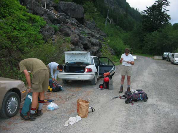
Dan, Victor, and Len: Packing and studying at the closure on the West
Side Road.
We left the cars at 2,880 ft. around 8:30 pm. We hiked along the closed road 4 miles up to Round Pass and then up the South Puyallup By-pass trail for .6 miles. Here we met up with the S. Puyallup trail which lead in 1.6 miles to the junction with the Wonderland trail and a campground (4,100 ft). It was about 10:30 now and we scrambled around through all the sites in camp only to find the place entirely full! We decided to "share" a campsite with a lone tent.
We woke up with low fog misting on us around 6:30 am. The guy who's campsite we had poached turned out to be from Salt Lake City and quite friendly. We ate breakfast and chatted for an hour, then it was off up the steep and switch-backed slope above the Puyallup river. 1,500 ft. later we gained the ridge crest and followed it until the trail begins to descend off the crest of the ridge. At this point we said goodbye to our camp friend who had been hiking with us and continued up a small climber's path on the crest.
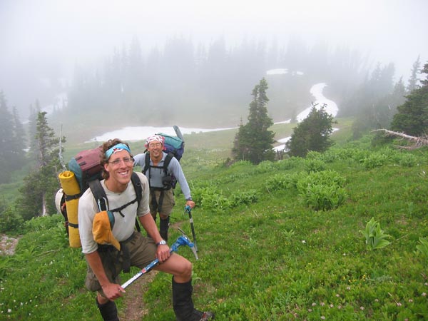
Dan and Victor on the ridge that leads up towards the Puyallup Cleaver.
After a loose traverse below a ridgeline and a short drop down, we came up into a meadow below Takaloo Spire. All of a sudden the mists began to part, and out came one of the most beautiful views of Mt. Rainier.
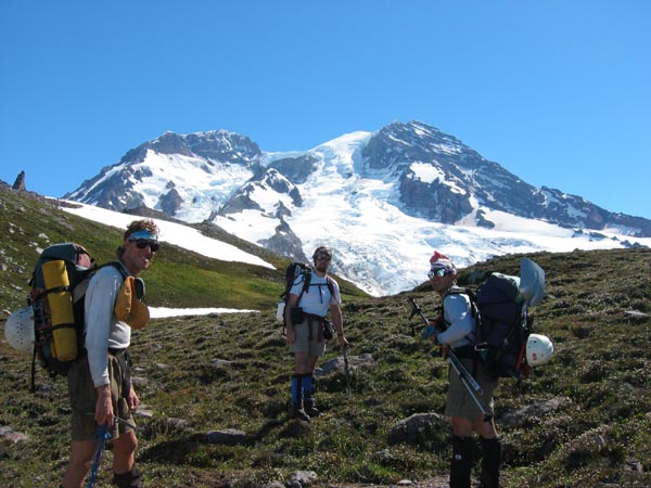
The guys pose infront of the Tahoma Glacier.
In the meadow we found a ptarmigan sitting contentedly by a rock. Earlier on the trail we had seen a newt-like amphibian. In a few minutes we would see a goat crossing the Tahoma glacier. The West side of Rainier truly is an animal paradise!
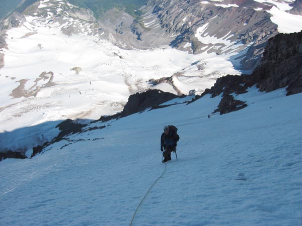
We contoured around the right side of Takaloo spire to the 7,500 ft. campsites on the Puyallup Cleaver. Someone with a little too much time on their hands had built a primitive stone henge of carins, and the views of Adams with the low clouds provided quite a gorgeous view. We hiked a little ways up the cleaver and then dropped onto the Puyallup glacier.

Victor heads out onto the Puyallup. We eventually went past the left hand
skyline!
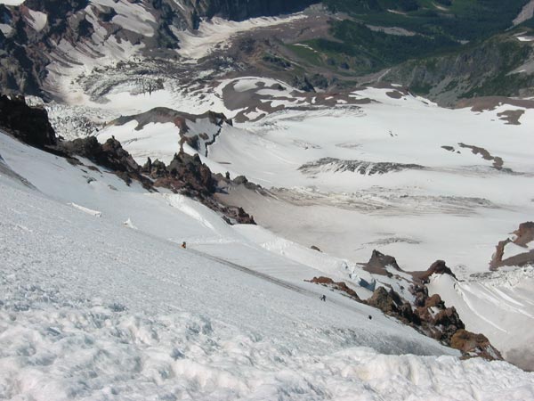
We dropped down a bit and then climbed up through small crevasses to the 8,000 ft. level where it is possible to traverse the upper part of the glacier. This lead us to a scree ridge which we climbed, past a nice campsite, at 8,300 ft. before dropping down onto the South Mowich glacier. We crossed over a little icefall and were able to fill up our water bottles in a nice slushy pool. We then dropped further down to skirt below the rock buttress of Sunset ridge (middle of picture above). The area was pretty exposed to rock and icefall so we moved quickly back up the other side of the ridge. We topped out on the slope below the Sunset ridge route, and then cut left to the ridge crest at 9,200 ft.
Dan and Victor heading towards the Col. below Sunset ridge's "face".
We could now see the nunatak at 9,600 ft. that was to be our camp, but another freakin' icefall blocked our way! We descended down, again, below the jumble and then back up the other side to the highest point along the rock spur.
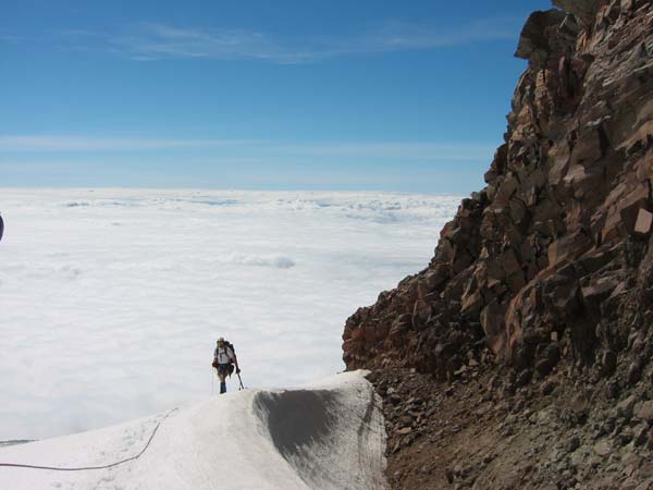
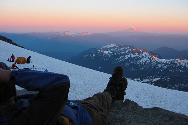
Len nearing camp at 9,600 ft above a sea of clouds.
It had taken us 9 hours to climb the 6,500 ft. in about 8 miles. Exhausting!
The camp wasn't quite what I had expected. There weren't any cleaned out rectangles of smooth ground with little rock wind walls like you find everywhere else. No, this place was still pristine. We spread out among the smooth flat rock slabs and the few small flat spots, glad to have only bivi bags. We had brought along enough fuel to melt water, but I noticed a tiny stream coming out of the icefall just above camp. Sure enough, we could fill our bottles directly from the base of the glacier. This became a common trend throughout the trip.

The Mowich face from camp. The Central face climbs directly up below the
ice-cliff on the left, then right to the highest point.
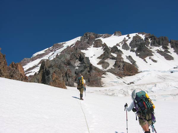
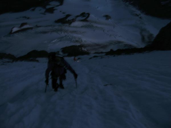
After a mere four hours of sleep we awoke to a blazingly bright moon setting. After melting some extra water and repacking we roped out of camp around 3 am. Dan lead the way with Len and Victor right behind us. Our first big obstacle was crossing the 'shrund at the base of the face. Dan weaved right around one of the biggest crevasses I've ever seen, and then back left to a sharp arete like snowbridge that lead onto the face above. After a few shenanigans we all began our ascent up the lower face.
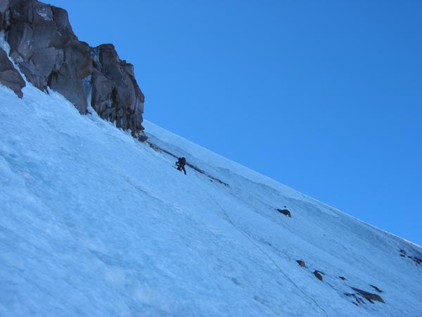
Len climbing up the lower part of the face.
The lower face was consistently 35-40 degrees, but good solid snow conditions helped our quick ascent up to 12,000 ft. For some reason, there was a small but constant flow of ice-shard spindrift coming down the face. Luckily no big rocks or ice came down the route while we were in this exposed part of the route.

The infamous hole on Rainier's Northwest side. You can actually see this
from Spray Park!

Len leading up steepening slopes near 12,000 ft.
From here we could clearly see the harder ice variation that cuts off right from the standard Central Mowich route. We had intended on doing this variation, but we saw an easy looking ramp cutting back left towards the icefall. We figured this was the standard way, and it looked like real easy ground up to the glacier above the face. After talking it over a bit we decided to check it out. Ooops..

Where are we toto?? Dan reaches the very base of the icecliff!
I had lead us up a gully and eventually up to the base of the ice cliff and off route. The route shows a gully paralleling the cliff on its right, so we decided to try and traverse our "ledge" system and see if the two routes would link up. After two pitches of snow, loose rock, WI 2 ice, and some fun mixed climbing I reached just exactly what I feared: a big-fat-cliffed-out-dead-end!
I came back to the belay shown above and we made the (correct) decision to back track to our original route and do things right. By the time we had returned to the face we had wasted a good two hours. However, we were all warmed up for ice climbing!
Dan traversing on the upper ice variation.
The surface had hardened considerably above 12,000 and thus required much more careful technique as well as a running belay. Dan and I had four ice screws, and we placed one each ropelength as we climbed up the 50-55 degree ice.
Dan leads up the steep ice crux of the route.
After traversing up and right for about 9 pitches we reached the gully that is the crux of the ice variation. This turned out to be some easier-than-it-looked 60 degree water ice up the side of the gully. Dan lead this section with great speed and style. Soon we were both on the final slopes leading to the peak of the Mowich face.
The sun was now shining down upon us as we looked up towards what seemed like a dream: flatter ground! The slope eased off to 40 degree ice but we continued the running belay due to the challenging ice conditions and big air under our feet. I lead off, and in about 5 pitches or so we had reached a little bench just below the top of the face. Dan and I decided to hang out, rehydrate and wait for Len and Victor to join us before pushing on.
Len and victor climbing the upper slopes of the Mowich Face.
We were all getting pretty tired due to the altitude (13,300 ft.) and our already large elevation gain from camp. After a nice long break, we popped over the top of the face and onto the ridge that leads to Liberty Cap. The snow was heavily suncupped and slushy which made for tricky footing as we ascended up the slope. We were all quite happy to transition from ankle-tweaking steep snow and ice to slog mode. After 800 ft of elevation gain and quite a fair walking distance we were on top of Liberty Cap (14,100 ft.). With our scenic detour and breaks, it had taken 12 hours from camp.

Dan on top of Liberty Cap, summit in the background. We had to go there
next.
Seeing as we were intending to carry over the mountain and descend down to Paradise, we had to climb up to the true summit. This, as anyone who has reached the saddle between Liberty Cap and Columbia Crest can tell you, is no easy task.
We hiked down to the col. between the peaks (13,600 ft.) and were able to refill our water bottles in yet another slush pool! This proved helpful on the ensuing slog up to the summit. After 900 vertical feet of mental numbing and rhythmic breathing, we all stood atop the mountain. It was 5:00 pm!
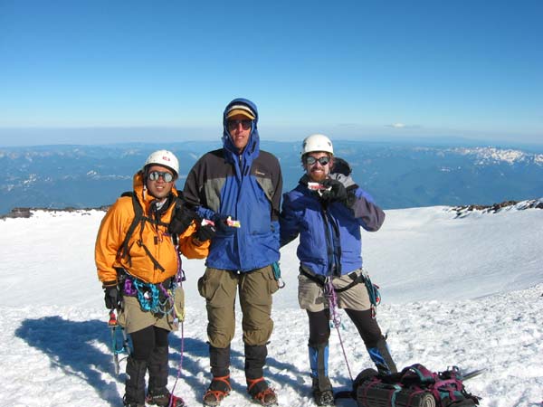
Len looking happier on the summit because he doesn't have to split his
Payday bar!
We were all very relieved, for movement upwards was now impossible. Unfortunately the day was not quite over for we couldn't find the teleporter that transfers one to the nearest restaurant. Instead we took a break before heading down across the crater towards the Disappointment Cleaver route.
I had never been up or down the DC, so it was quite strange to come upon the shoveled out trough of the route. We began zooming down the "switchbacks" with legs cramping and feet a hurtin'. Around 13,000 we met three sets of RMI guided teams headed up the mountain. Apparently they now offer "night climbs". At their pace, we doubted whether they would catch even the sunset!
The cleaver itself was still snow-covered, so we made quick time down to the ingraham flats camp. After traversing and descending through Cathedral gap, we walzed (read: limped) into camp Muir at 9 pm. It had taken us a little under 3 hours to descend. Whew!
Reeeeeeelaxin' at Muir, watching the sun set.
For a while we had toyed with the idea of spending the night at Muir, but the desire to eat real food and the nearly full moon compelled us to go all the way out. This was probably a good thing, for I don't know how much sleep we would have gotten that night. Muir was alive with weekend climbers coming and going at all hours. It is quite amazing to see the range of people that attempt this route. We saw everything from plush expedition tents to guys sleeping on the ground under camo tarps with their boots and crampons already on!
Soon we began the death march down the snowfield towards Paradise. My knees were really beginning to hurt from the day's pounding and thus I moved much slower than the other three. However, the full moon was inspiring and it brightly lit the way down to the inviting lights of the lodge. Just shy of midnight, we stumbled into the parking lot. By the time we had driven down to fetch the other car, our watch alarms began to go off. It was now officially a 24 hour day.

Our route over the mountain from the West Side Road to Paradise. Camps
at yellow dots.
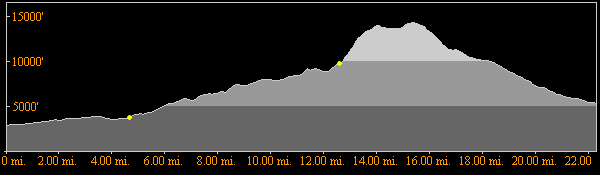
From left to right, the elevation and distance profile for our trip.
Surprisingly, there was very little open in Eatonville and such places along the drive home. Finally, relief from hunger was found at Shari's fine dining in South Hill. However, seeing as it was 2:30 in the morning, we all opted for breakfast!
The Mowich Face was truly an adventure. We found wildlife, a whole new side of the mountain, and challenging climbing. Our approach was certainly longer and more difficult than a start from the Mowich lake side, but it did provide us with an easy car shuttle and straitforeward descent. In all, we ascended almost exactly 14,400 ft to the summit, and covered 22.5 miles car to car. Sleep could not come any sooner as the the second sunrise of the day began.